
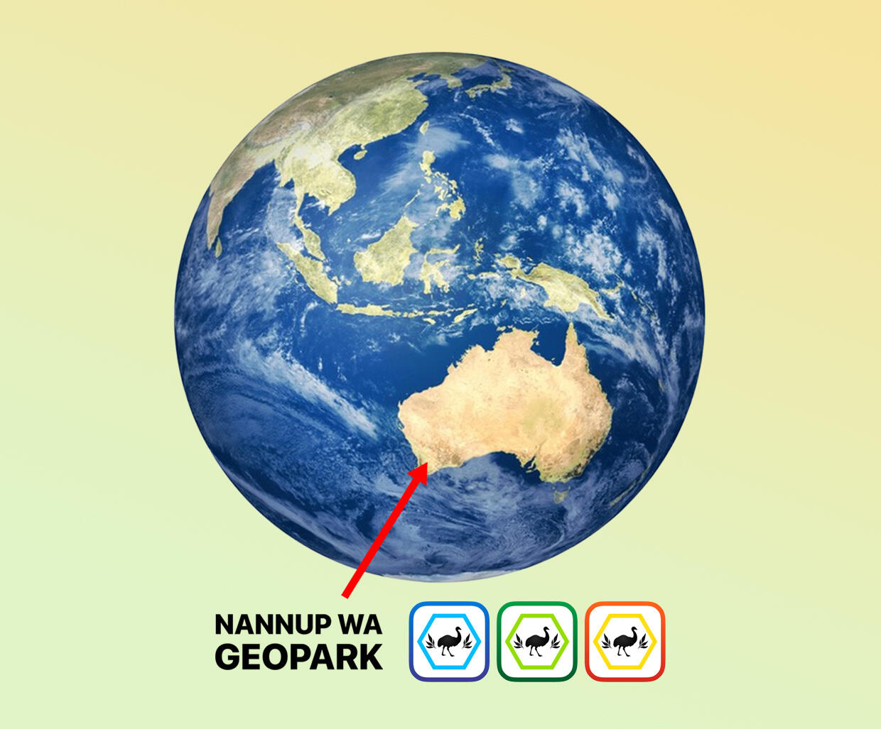
Nannup WA Geopark
Billions of Years in the Making
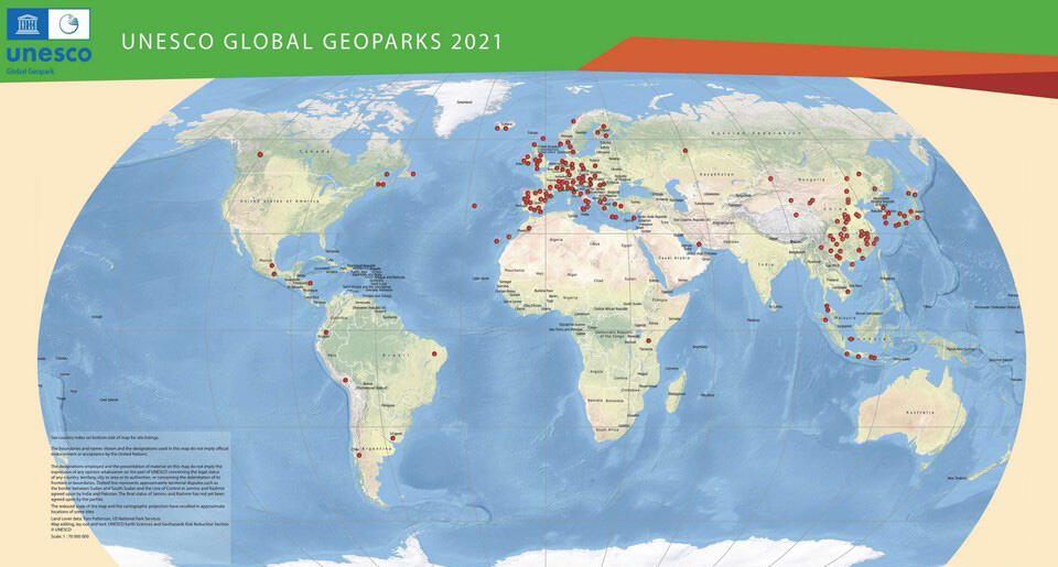
Nannup is striving to become a UNESCO Global Geopark

Geopark Networks

Become a Member

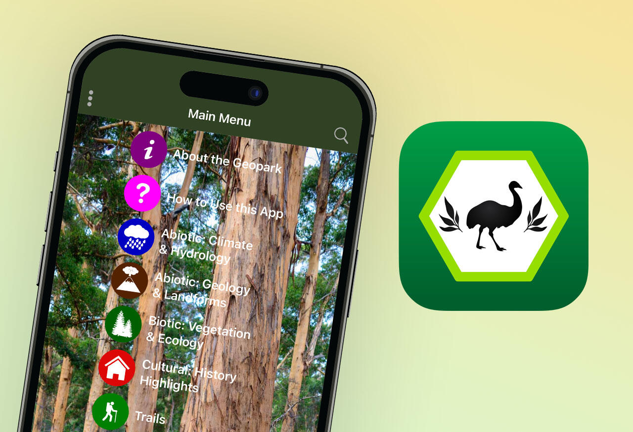
Geopark App

Geopark Goals

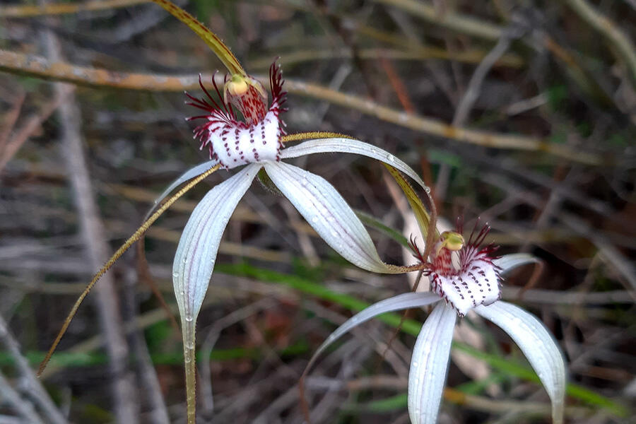
Why Nannup WA?

Geopark Display
What is a Global Geopark?
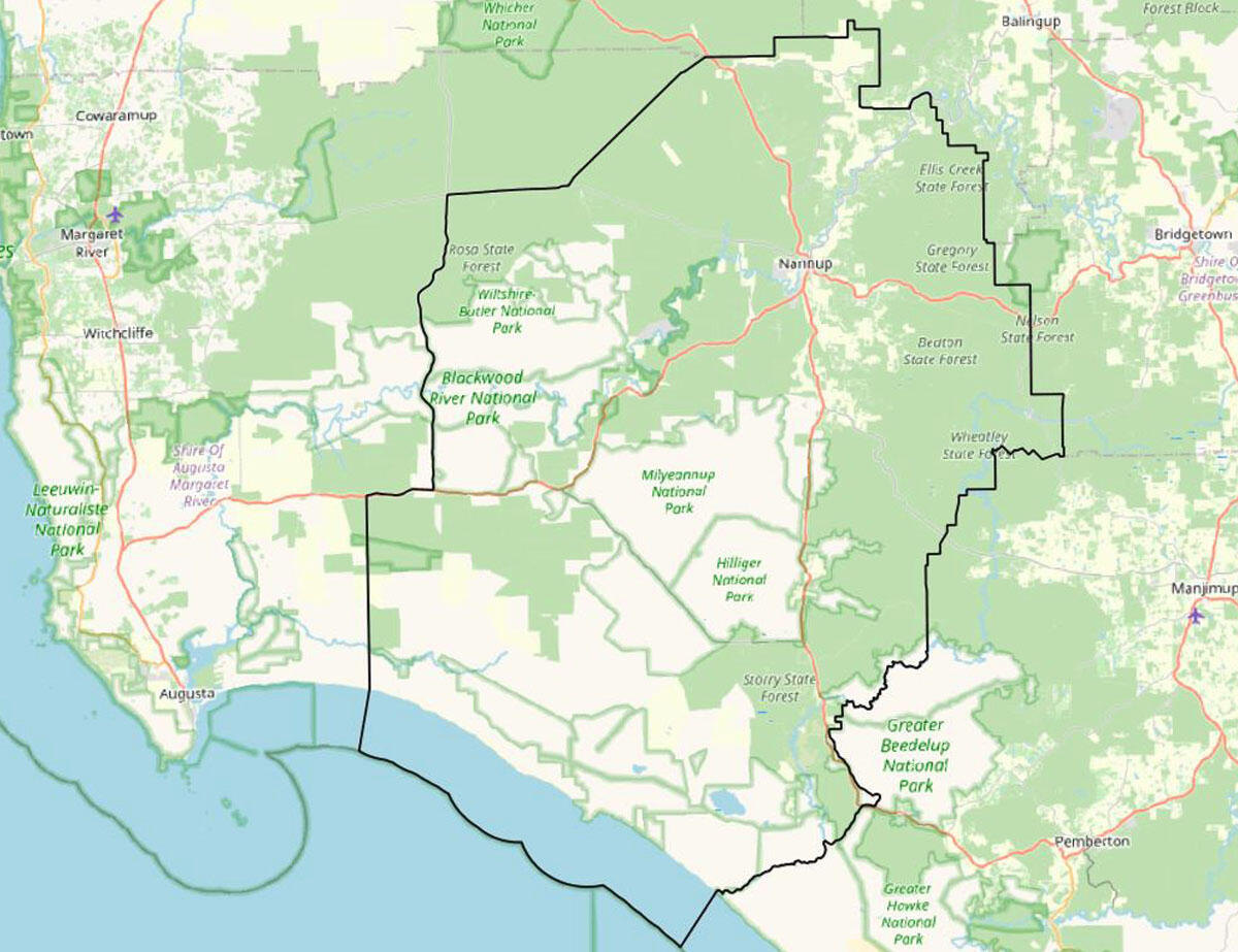
A geopark is the collation of information over an area, that highlights the importance of the region’s unique geological, biotic and cultural heritage. The area is not defined by land tenure or titles.The Nannup WA Geopark is within the Nannup Shire Boundary. The uniqueness of a geological site of international significance is a requirement to become an accredited UNESCO Geopark. They also must be managed in a holistic concept of protection, education and sustainable development.While the geology is the foundation of a geopark, they are not geological parks. The term “geo” in geopark originates from the Latin word 'Gaia', meaning earth and land. Geoparks connect the geological heritage of a region with its cultural, social, and natural heritage - so more like an Earth-Park.
What are the criteria for Nannup WA Geopark?
Geology natural heritage and culture are broken up into what UNESCO refer to as the ABC’s - defined below.
A - Relates to the ABIOTIC: the geology and climate of the area.
B - Relates to the BIOTIC: plants and living organisms of the area.
C - Relates to CULTURE: past and present indigenous culture, as well as post-settlement culture that has shaped the area we see today.
See the following facts below that support the application to become a UNESCO Accredited Geopark.
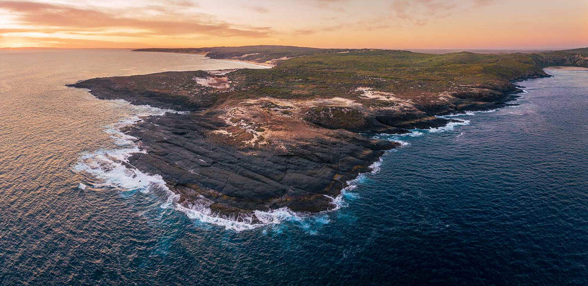
Special attributes to Nannup WA Geopark
Abiotic
The geology of the area ranges over 2 billion years.
Includes lava flows of 220 km running along two 130 million year old valleys.
Basalt lava flowed from well to the south of Black Point, past Nannup, to the north of Bunbury.
Up to 9 km of sediments deposited from Antartica during the time of the dinosaurs - between 100 and 300 million years ago.
Much older metamorphic rocks, over 2,600 million years old and more than half the total age of Earth.
Biotic
Large and intact natural areas with significant features.
Sits within the South-west of Australian Ecoregion, one of the world’s 36 biodiversity hotspots.
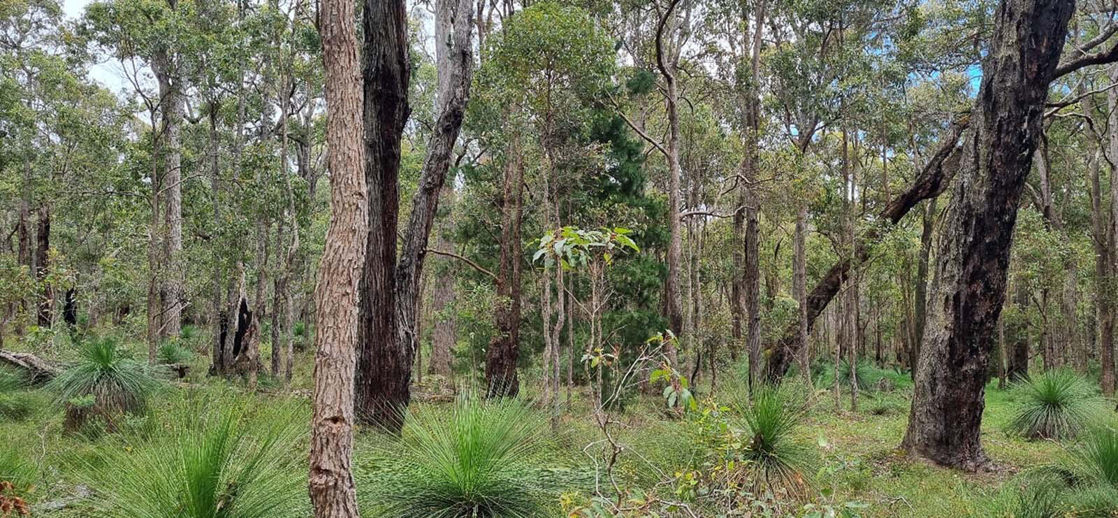
Over 85% of the land is covered by native vegetation, including Eucalypt forests and woodlands containing endemic flora and fauna with Gondwana links.
30% of the vegetation is reserved as National Park and a further 60% is State Forest where native timber is protected from logging.
The Gingilgp-Jasper Wetlands is of national significance and the South-west's greatest river, the Blackwood.
Over 200 km2 of marine environment.
Culture
The Nannup WA Geopark area is a place of rich cultural heritage.
Nannup (stopping place) has been occupied and managed by the Noongar peoples for over 40,000 years.
European settlement has played an important part in shaping the area as it is today.
Keen to explore? Get the Nannup Geopark App
GPS-enabled Walking Trails, Offline Access, Detailed Maps and more.
In Development
Geopark Static Display
Coming soon from Nannup WA Geopark
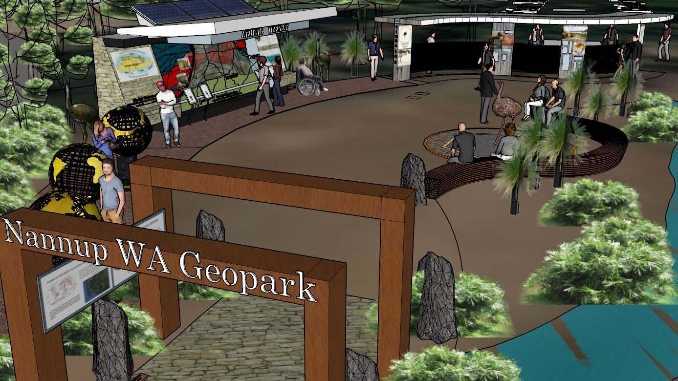
Proposed Display Site
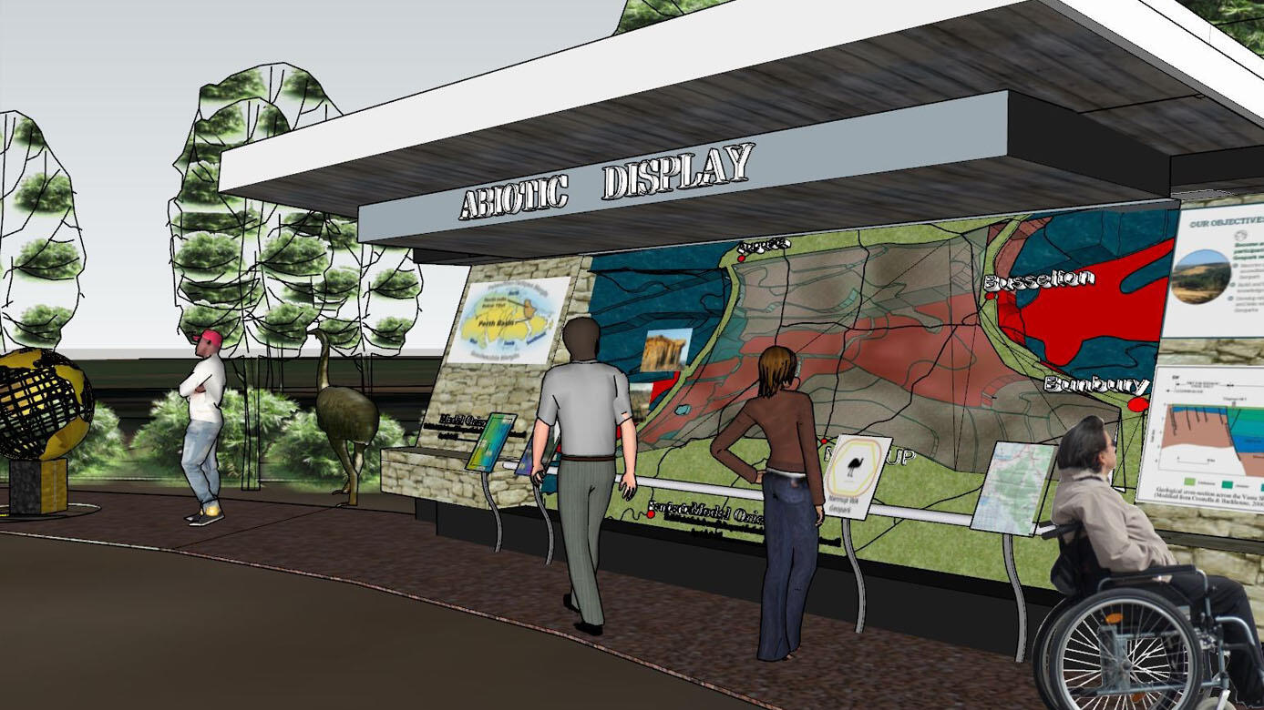
A site has had conditional development approval from the Shire of Nannup for the construction of the proposed Static Display by the Nannup WA Geopark. This display is intended as the focal point for visitors to the Geopark.Currently, all that is to be seen at this stop is the location for this exciting development. While street parking here is not suitable, you can park your vehicle nearby, either at the Nannup Recreation and Community Centre (entry via Centenary Drive 60 metres to the south of this stop) or at the Marinko Tomas Memorial (entry 160 metres to the north of this stop) where there are public toilets, picnic facilities and a playground.The following images are the initial concepts of Stage 1 prepared for Nannup WA Geopark by Paul Meschiati and Associates.
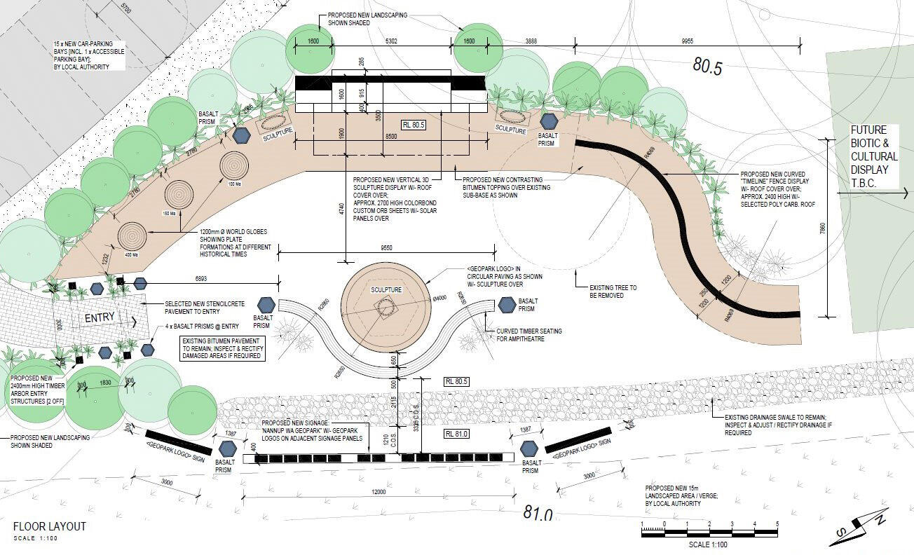
Stage 1 - Abiotic Display
Stage 1 of the display will concentrate on the Geopark’s Abiotic (geological) features and will include:
A large 3D sculpture of the geopark highlighting the depth of the Perth Basin and the paths of the Bunbury Basalt flows;
Three world globes highlighting the tectonic movement of the contents before and following the breakup of Gondwana; and
A time-line fence comparing the geological history of the earth to a calendar year.

View of proposed display with globes highlighting continental drift on the left

3-D model in proposed Geopark Static Display
Future Development
Once Stage 1 is complete, planning will commence for two future stages highlighting Biotic (flora and fauna) and Cultural features of the Geopark.
Affordable + Educational
Get the Nannup WA Geopark App
What Do You Get in the App?
As an individual (or group), the $2.99 you spend to get the Nannup WA Geopark App will provide endless hours of interactive fun for you, your friends and family members when you visit the area.
Complete offline map access with optional GPS tracking for accurate and uninterrupted use with your smartphone
Detailed information of locations, landmarks, trails and more - no internet access required once installed
Ability to bookmark any listing to create your own 'to do' list of places to visit
Broad range of educational material suitable to schools and educational groups
Become part of history with citizen science programs
For iPhone

For Android Phones


Help Support Us to Support You
You help the Nannup WA Geopark team when you download the Nannup WA Geopark App.For just $2.99, along with many hours of activities and entertainment, your small fee helps the Nannup WA Geopark volunteers create information and develop programs for educational and citizen science programs for the Nannup WA Geopark.
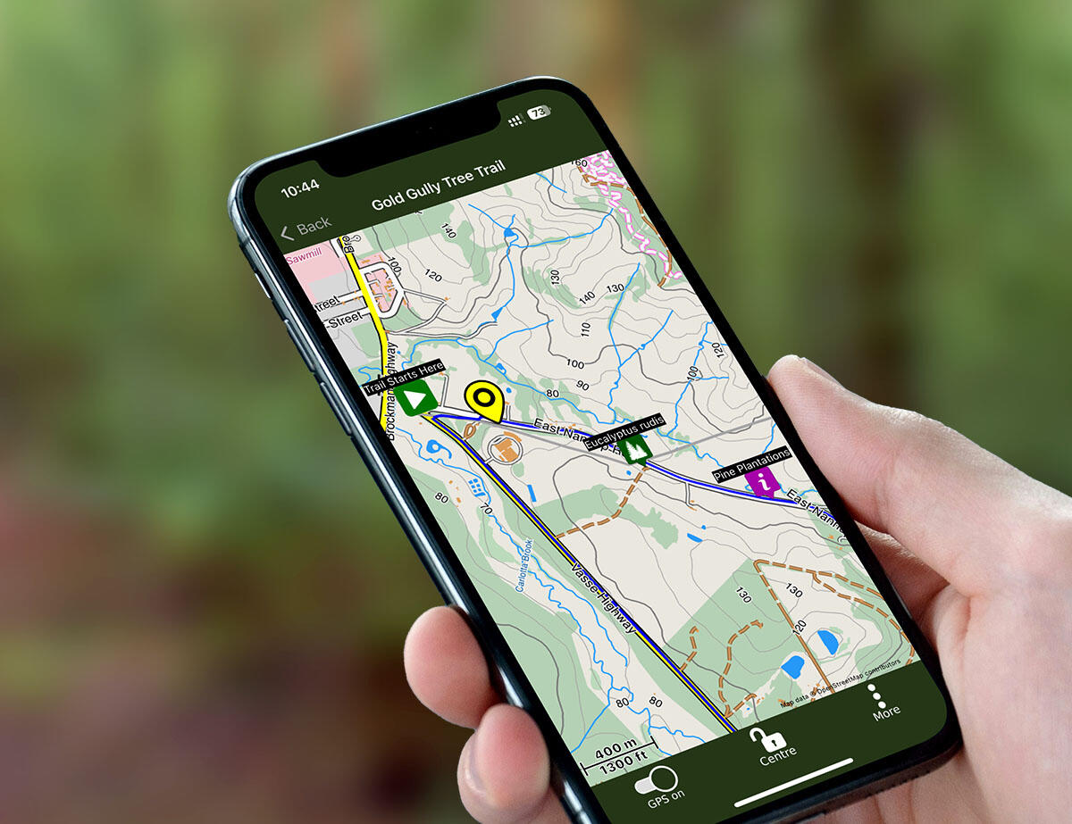
Where Can You Use the App?
You can use the app anywhere. Once you download the Nannup WA Geopark app you have full access to the information for the Nannup WA Geopark.When you visit the Nannup WA Geopark you can enjoy GPS tracking within the entire Nannup WA Geopark boundaries.The app also works offline, so you don't require an internet connection to use it.
Nannup WA Geopark
Our Goals + Objectives
What we aim to achieve with Nannup WA Geopark
The Guidelines
The Nannup WA Geopark team developed Goals and Objectives in alignment with the goals and objectives of UNESCO Global Geoparks. This policy will enable a smooth transition from an aspiring Geopark to an accredited UNESCO Global Geopark.The Nannup WA Geopark team fully understand that we hold no legal tenure over the area of our perceptual boundary which is the Nannup Shire Boundary. We cannot allow access or deny access. UNESCO Global Geoparks are not like National Parks which are protected by legislation within the country they are designated.
The Nannup WA Geopark is not a lobby group or can it be used as a lobby group but rather a group of volunteers sharing there broad knowledge of the area to the public.Our Goals and Objectives to guide the Nannup WA Geopark team to deliver high quality information and develop interactive educational material along with citizen science programs. These are listed below.
Become Active Within the Global Geopark Network
Become a fully accredited UNESCO Global Geopark based on the boundaries of the Shire of Nannup, Western Australia
Build and freely share knowledge of the Nannup Geopark with the Global UNESCO network and develop relationships and links with other geoparks to enhance understanding and effectiveness.
Enhance Education and Knowledge Sharing Through Storytelling
Reveal, enhance and share knowledge of the unique abiotic, biotic, and cultural aspects of the Nannup Geopark to encourage protection, conservation, education, and appreciation of this ancient place for both current and future generations.
Tell the whole story of the interconnection between Nannup’s ancient geology, diverse landforms, vegetation and wildlife, indigenous culture both past and present and recent history to raise awareness of the region’s unique natural surroundings.
Foster and facilitate the development of research capability and educational materials to enhance knowledge of the Nannup Geopark region.
Provide Sustainable Economic Development Opportunities for the Nannup Region
Co-operate with like-minded entities and individuals, locally and internationally, to add value to the tourism experience in the Nannup Shire and promote sustainable economic development.
Develop a sustainable and accessible Geopark through a focus on digital technology and self-serve information sources.
Join our Research team
Become a Citizen Scientist
The Nannup WA Geopark is an exciting initiative that combines geological and ecological awareness and education and research, focusing on the understanding of local environments and historical significance

About the Carbon Project (SCEA)

What You Need

What Is Carbon Sequestration?

SCEA Results

Tree Guide

Educational Tutorials
Research Activity: Sequestered Carbon Evaluation Activity (SCEA)
The Carbon project is the first of the Nannup WA Geopark research projects.
Objective: The SCEA is designed to engage students and Citizen Scientists in measuring and evaluating carbon sequestration in both native and exotic standing trees within the Geopark region.
Focus: This project emphasizes the importance of understanding carbon storage within local ecosystems and empowers participants with the skills to measure and assess this vital process.
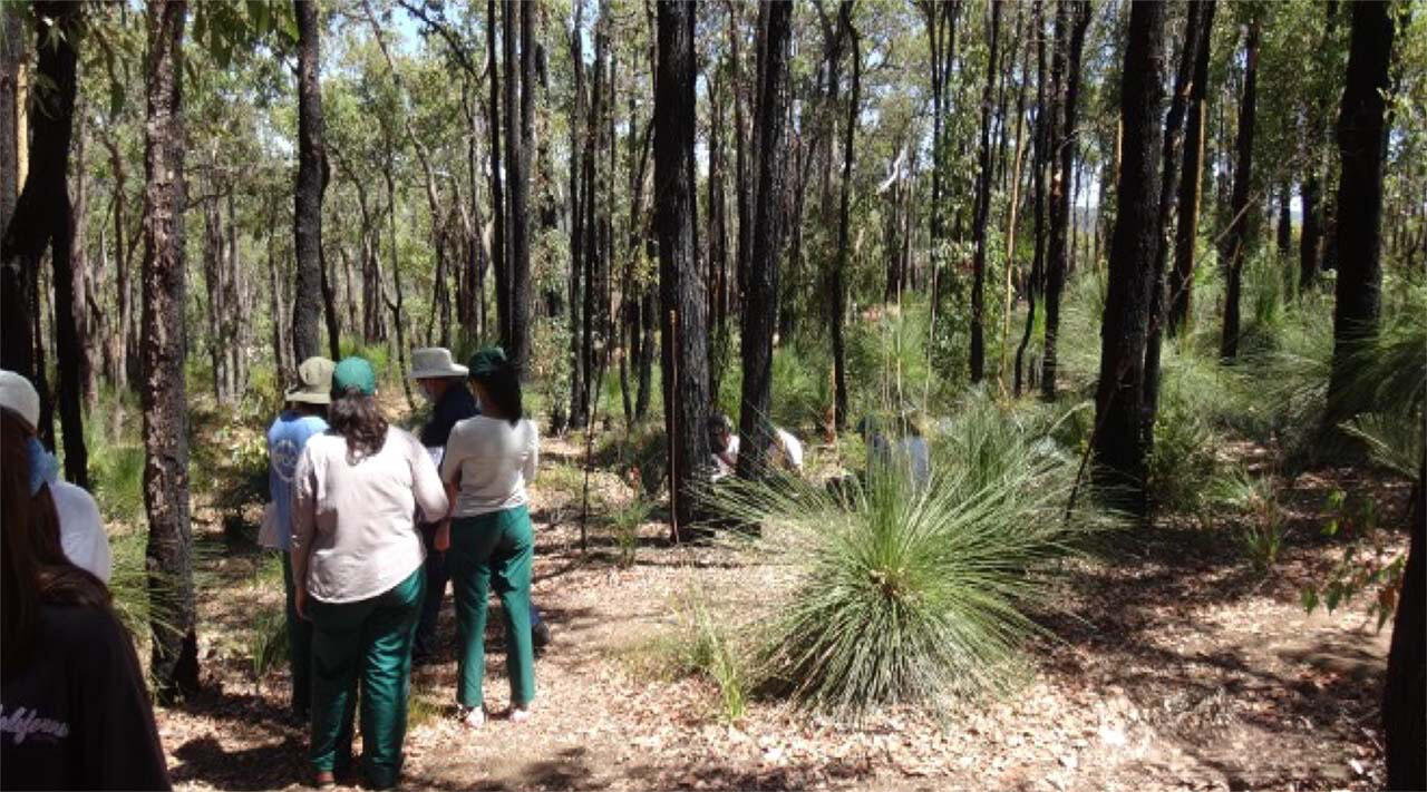
Cation name Location 1 bush: Marri and Jarrah ready to be measured
Everything You Need To Do SCEA
STEP 1 - Download the Nannup WA Geopark App
This will allow you to find the measuring points on the app. By using the GPS-enabled app you can find each SCEA measuring location easily. Please note the app has a one-off cost of $2.99.
STEP 2 - Download SCEA Field Instructions
To successfully obtain recordings and maintain data accuracy, please download the field instructions beforehand.

STEP 3 - Download Carbon Recording Sheet
This excel spreadsheet is required to record your results. Ensure you do this before you commence your Carbon Measurement Activity as internet connectivity is very limited at the Carbon trail site.

STEP 4 - Collect a Carbon Measuring Kit
You will need to hire a Carbon Measuring Kit from the Nannup Community Resource Centre (10 Warren Road) during weekdays and from The Wild Eyed Shop (33 Warren Road) on weekends.
Survey tape (30m)
Tree height clinometer (Suunto)
Dendrometer (Factor gauge)
Litter load gauge
Flagging tape
2x pin flags
The total cost for a 1-day hire is $20 per kit. Schools receive a discount when hiring kits in multiple numbers.


Congratulations! You are now ready to become a scientist and become part of history.
Carbon Sequestration Background Info
Carbon - Its Genesis
Carbon is an essential element for organic life on Earth, and it came into existence long before the Earth formed, and continues to be created throughout the Universe. Carbon is only formed under the extreme pressure and temperature present within aging stars nearing the end of their existence.The element forming process, termed stella nucleosynthesis, commences when the amount of hydrogen (H) within a star falls to a critically low level. At this stage, carbon nuclei are formed, with each carbon nucleus formed by the fusion of three (3) helium (He) nuclei, termed the triple-alpha process.
Once formed, carbon and the other newly formed elements (mainly heavy elements), begin their dispersal throughout the cosmos as the dying star collapses then explodes, termed a supernova, at the end of its life. The dispersed elements mix with interstellar dust and gases, eventually aggregating, over millions of years, to form new stars and planets. Recycling at a mega-scale. The Joni Mitchell song, “Woodstock”, is right in saying “We are stardust, we are golden, we are billion year-old carbon”.Our planet, Earth, is now about 4.54 billion years old, approximately half-way through its natural existence, with the first microbial life appearing 3.7 to 3.5 billion years ago, possibly earlier. Earth will cease to exist in about 4.5 billion years. However, complex life on Earth, in whatever form it exists then, will have ceased, or migrated to another planet, many millions of years earlier due to the immense, overwhelming heat from the Sun, it having become a raging red giant.
Carbon - The Element
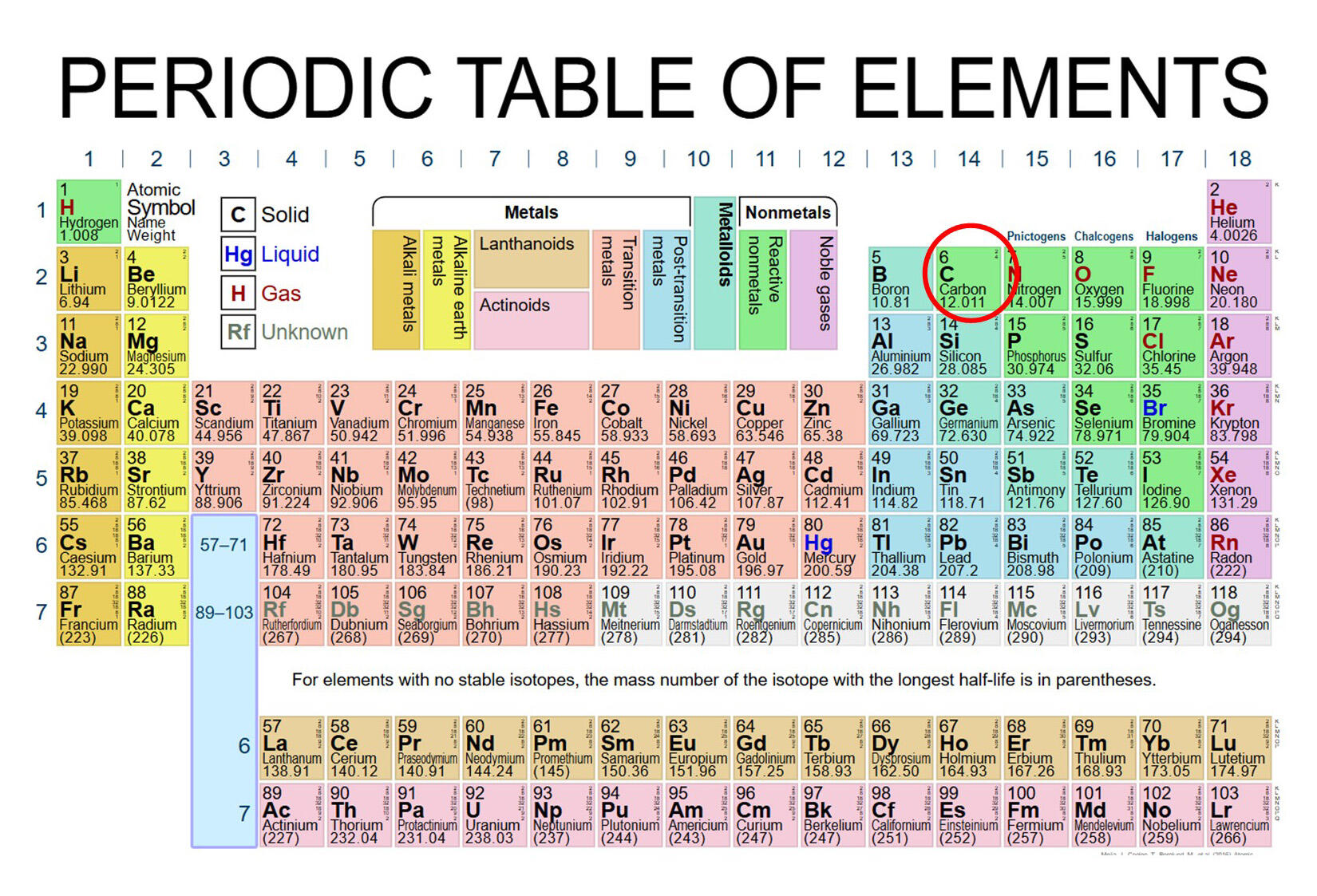
Carbon is a non-metal, number 6 on the Periodic Table in the second row, together with other reactive non-metals such as oxygen (O) and nitrogen (N). See Periodic Table below.
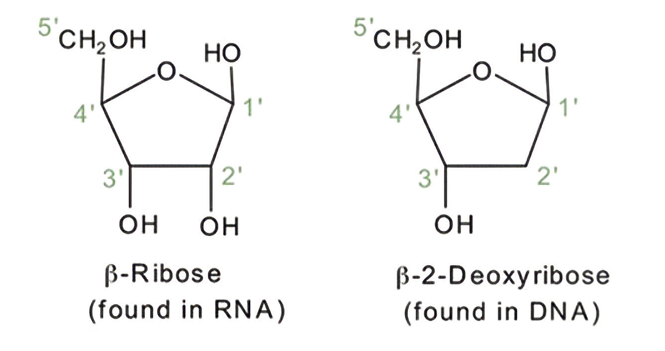
A carbon atom has a nucleus of six (6) protons and six (6) neutrons, with six (6) electrons orbiting the nucleus; two (2) electrons in the inner shell and four (4) in the outer shell.With this atomic structure, carbon has the unique ability to form four (4) very strong covalent bonds with other carbon atoms and many other elements. It is this atomic structure which makes carbon (C) such a critically important and versatile element, able to form the basis of life on Earth.Carbon forms nucleic acid, the fundamental compound for building all life as we know it. Nucleic acid has two (2) forms, namely, ß-Ribose, found in RNA (ribonucleic acid) and ß-2 Deoxyribose found in DNA (deoxyribonucleic acid). See atomic diagrams below.
Carbon Atomic Structure
Earth's Carbon Cycles
As with other elements and compounds comprising Earth, carbon (C) moves in various cycles, moving at various rates between reservoirs and with various residence periods within reservoirs. Whilst complicated in detail, carbon cycles can be generalised into short (< 1 minute – 24 hours), medium (1 day to 1,000 years) and long term (1,000 years to millions of years) cycles.In the short cycle, carbon moves quickly from the atmosphere into plants, soil and organisms. For example, carbon, as carbon dioxide (CO₂), is absorbed by plants through the process of photosynthesis within leaves and then converted into sugar, O₂ and then into various tissues. This process occurs in leaves and is illustrated in the diagram below.
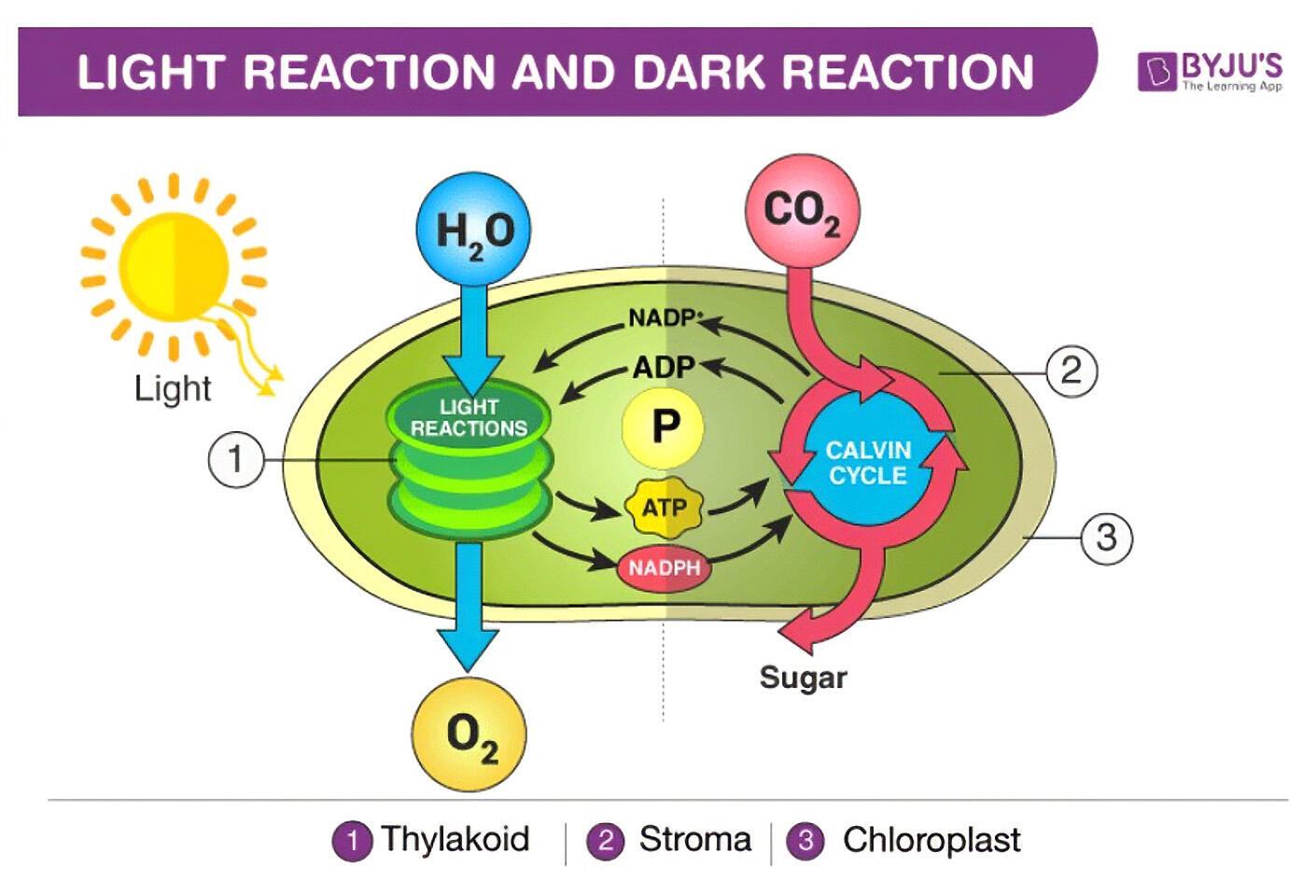
Carbon Earth Cycles (Credit: ByJu’s – The Learning App)
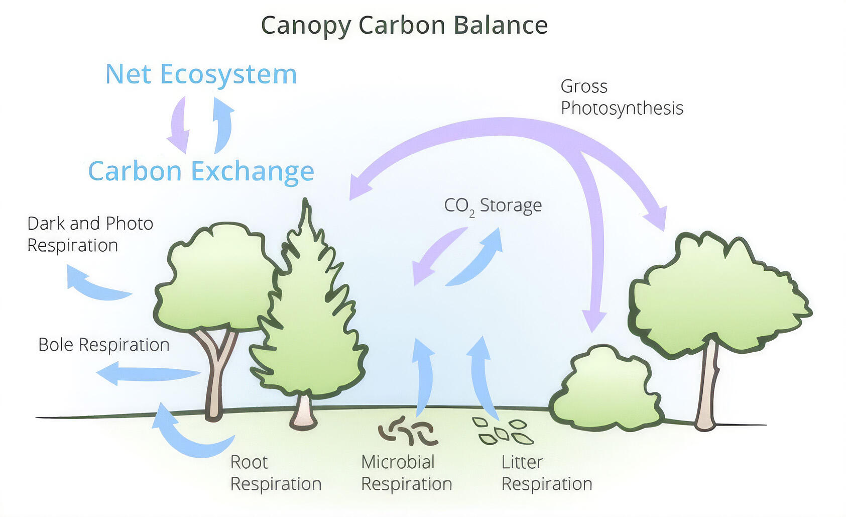
The process of fixing carbon as plant tissue, mainly as cellulose created from sugar, is termed sequestration. Some carbon is transferred into soil via root enzymes and fungi, and to animals via herbivory. Additional information on the sequestration of carbon by plants is provided in Section 4.In the medium cycle, an example particularly applicable to the SCEA field activity, is the gradual growth, accumulation of carbon in woody tissue (sequestration), aging and death of a large tree, then the wood decaying releasing carbon into the atmosphere, soil and to those organisms consuming the wood, the process taking place over 100 to 400 years; to +1,000 years in some cases. The diagram below illustrates the CO₂ (mauve arrows) and O₂ (blue arrows) pathways between the atmosphere, plants and soil.
Canopy Carbon Project
In the long cycle, an example is the rapid burial of trees and other vegetation forms by soil and/or sediments (sedimentation over geological time) eventually to form coal over millions of years of deep burial. Coal is an energy-rich material because of the high carbon content, which when burnt, releases large amounts of heat (used to make steam to power engines) and large amounts of ‘waste’ carbon in the form of charcoal, and carbon dioxide (CO₂) and methane (CH₄) gases; the gases rejoin the atmospheric reservoir. The CO₂ then becomes available again for absorption by plants, millions of years after its previous absorption by plants.Importantly, Earth’s oceans, lakes and rivers also play very important roles in the carbon cycling process at all scales.The diagram below and its associated data illustrates the global or long, also known as the slow, carbon (C) pathways between the atmosphere, industrial operations, plants, soil and very long-term geological burial. Also provided are some facts about the carbon cycle. Mt means Million tonnes; M years means Million years. Data is sourced from NASA Earth Observatory, May 2023.
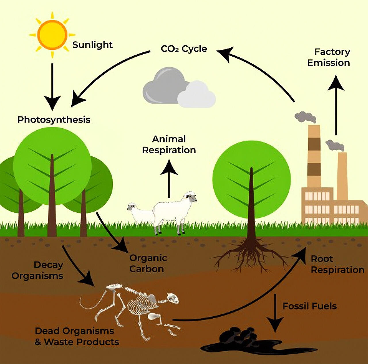
Some Carbon Cycle Facts
100 - 200 M years to complete cycle,
C moves through various major inorganic and organic reservoirs: Earth’s atmosphere, Oceans, Plants and animals, Soil and rocks
10 – 100 Mt C moves through the slow cycle each year.
Importance of Carbon Sequestration by Plants
Carbon in the form of carbon dioxide (CO₂) is absorbed from the atmosphere by plants and then converted into energy (sugars) and tissue (mainly cellulose) for growth - this process is called photosynthesis. Excess oxygen (O₂) resulting from the disassociation (break-up) of CO₂ not required by plants is released into the atmosphere – this is the oxygen that we breath; without this oxygen, almost all organisms on Earth would not be able to survive without major, fundamental change to their metabolic processes.The oxygen retained by plants is eventually combined with carbon and hydrogen (from water) to synthesise sugars then into cellulose (C₆H₁₀O₀), which comprises 40 – 50% by weight of wood, to form the roots, trunk and branches, is how most of the carbon is stored and is then called sequestered carbon.Carbon sequestration plays a crucial role in keeping Earth habitable. This is because it helps regulate the planet’s carbon cycle and limits the buildup of atmospheric carbon dioxide, a major driver of global warming.At its core, carbon sequestration is the long term capture and storage of carbon in plants, soils, oceans and geological formations. By stabilizing carbon in these reservoirs rather than allowing accumulation in the atmosphere, sequestration reduces the greenhouse effect and slows climate change.This process is profoundly important for life on Earth. Rising CO₂ levels intensify heat retention by the atmosphere and oceans, in turn disrupting weather patterns, and threatening ecosystems on which humans and most other species depend. Natural sequestration by forests, woodlands, grasslands, wetlands and oceans act as buffers, absorbing a significant portion of human-generated emissions, thus helping to maintain climate stability. Maintaining, or enhancing these natural systems if degraded, mitigate the impacts of human industrial activity and protect biodiversity.As climate change intensifies, reducing emissions alone is no longer sufficient. Thus, removing excess carbon from the atmosphere is essential for safeguarding global health. Carbon sequestration is a critical, primary natural process that supports the long term resilience of life on Earth.
Characterisation Terms For Tree Sequestered Carbon
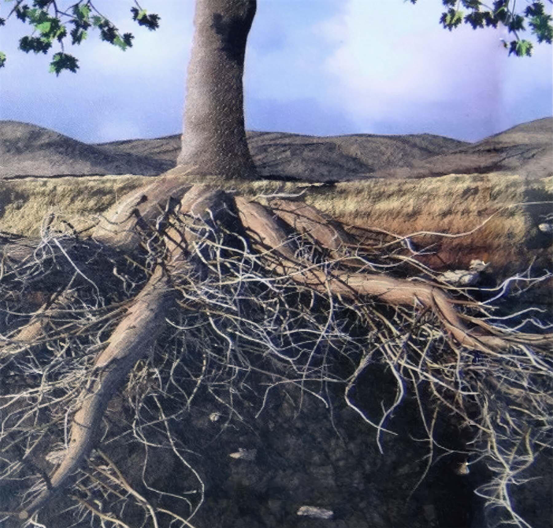
In the science of tree sequestered carbon, there are a number of terms used with specific meanings; these are described below.Carbon stock (tC or tCO₂ equiv.): this is the amount of carbon (in units of tonnes carbon or carbon dioxide equivalent), called ‘green carbon’, stored in land plants or in the case of offshore seagrass meadows, called ‘blue carbon’. The stock calculation may or may not include plant roots but does need to be stipulated. The calculations for SCEA do include the tree roots.Partitioning of carbon stocks above- and below-ground: when measuring the amount of carbon by plants, whether grasses, shrubs or trees, it is good practice to distinguish carbon held above-ground level in the stems or trunks and branches, as distinct from the carbon held below-ground in the root system. The reason for the distinction or partitioning is that it is much more difficult to measure root-hosted carbon accurately compared to the above-ground portions of a plant.
For the SCEA field activity, the term “estimation” rather than “measurement” is used so as to not imply a high degree of accuracy when root-hosted carbon is included in the calculation. SCEA uses a root carbon ratio of 0.3 of the above-ground carbon held by the trunk and branches.The illustration below shows the below-ground root system and the above-ground trunk of a tree.
Carbon density (tC/Ha or tCO₂ equiv./Ha): this is the amount of carbon stored in plants in a hectare (an area 100m x 100m or circle radius of 56m) of land or offshore in a seagrass meadow. At the SCEA designated forest sites, the estimation area is one (1) hectare, thus the resultant calculation of the amount of above- and below-ground carbon (C) is the carbon density at that site.Spatial and temporal variability of carbon density: Adding to the difficulty of measuring carbon stocks in vegetation, whether on land or offshore, is the variation between measurement sites even within the same vegetation type. This spatial variation is caused by natural (intrinsic) variations in factors such as soil, position on landforms (e.g. hill tops to valleys), aspect (e.g. north-facing slopes compared with south-facing slopes) and the amount of rock outcrop.In addition to natural variation, there is usually variation caused by human activity and land use such as farming, logging/thinning and clearing for tracks and infrastructure such as dams, power transmission lines and water pipelines.Temporal variation is the variation, both natural and human-induced, through time at short-, medium-and long-timescales. Climate change, both natural and human-induced has a significant effect on the type and density of vegetation in an area, and thus on the amount of carbon sequestered.
Why Is Measuring Sequestered Carbon Important?
The quantity of carbon comprising the woody tissue of trees is estimated in the field by the Sequestered Carbon Estimation Activity (SCEA). It is anticipated that over many years and many SCEA measurements being undertaken by keen Citizen Scientists that a comprehensive database of sequestered carbon estimates will provide an excellent spatial and temporal record of forest-sequestered carbon throughout the Nannup WA Geopark. It is a valuable and informative component of monitoring the health of the forests.In essence, “What is not measured, cannot be managed.” Thus, your interest and participation in this activity is very much valued and appreciated.Other supporting measures of forest health such as tree canopy cover, ratio of juvenile to mature trees, ground storey plant density and species composition, and fauna surveys are not part of the SCEA.
Worldwide and Australia's Carbon Emissions
World-wide, humanity has added a huge amount of greenhouse gas to Earth’s atmosphere, equivalent to approximately 2.44 trillion tonnes of carbon dioxide.Australia’s cumulative emissions of greenhouse gas by 2005 amounted to approximately 610 Mt CO₂ equivalent, with cumulative emissions to 2025 reduced to approximately 440 Mt CO₂ equivalent, and projected to continue to reduce as mitigation activities and technology continue to impact through to 2035 and beyond (source report: Australia’s emissions projects 2025. Australian Government, Department of Climate Change, Energy, the Environment and Water, November 2025).
Tree Guide for SCEA Sites
Selected Trees Found at or in the Vicinity of SCEA Sites
Karri
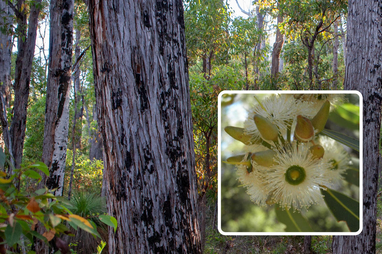
Karri (Eucalyptus diversicolor) is a very tall tree to 90m height, has smooth, pale grey and cream bark which peels off in long sheets accumulating at the tree base; Sep - Feb flowering (white).
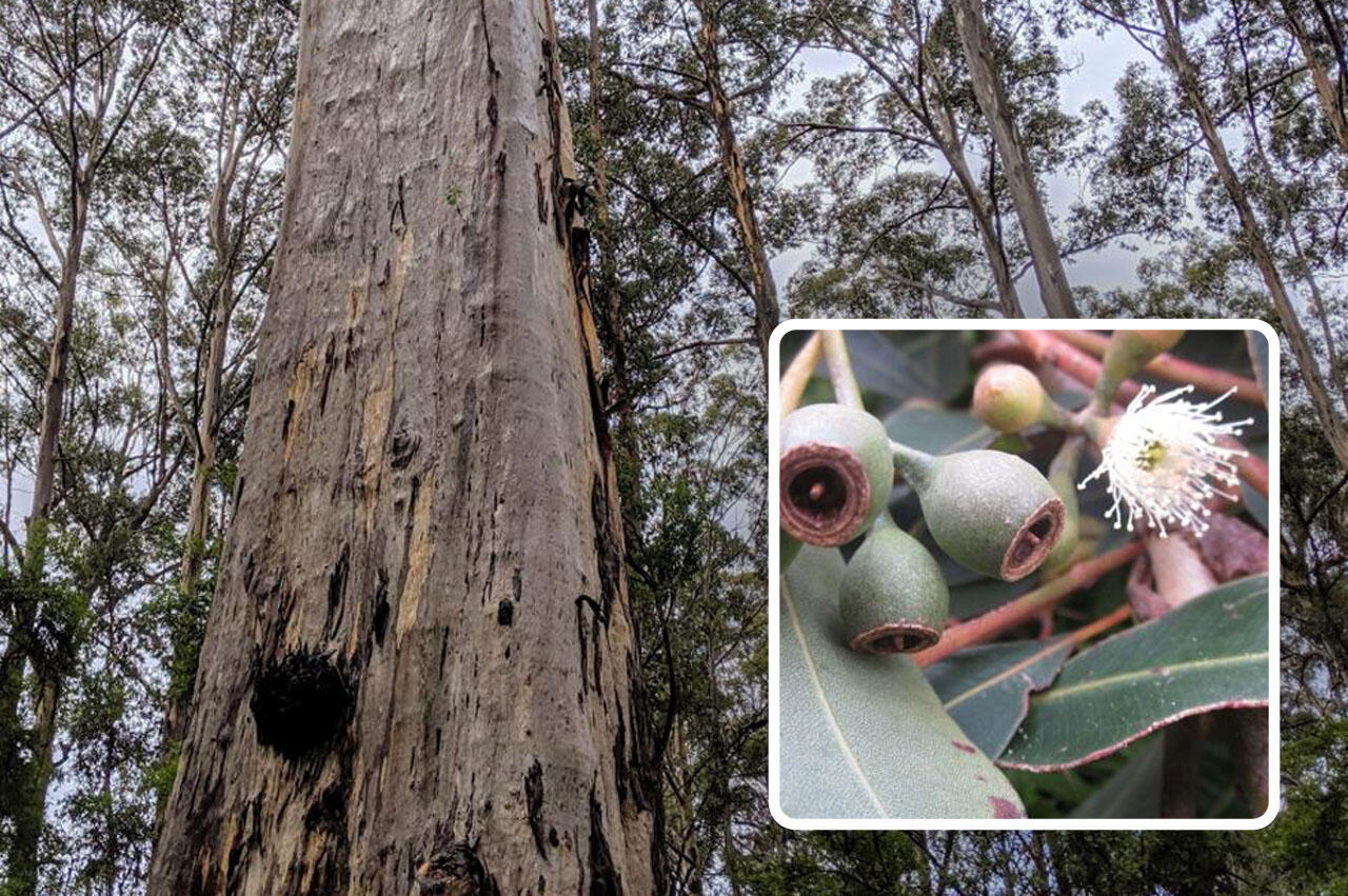
Marri
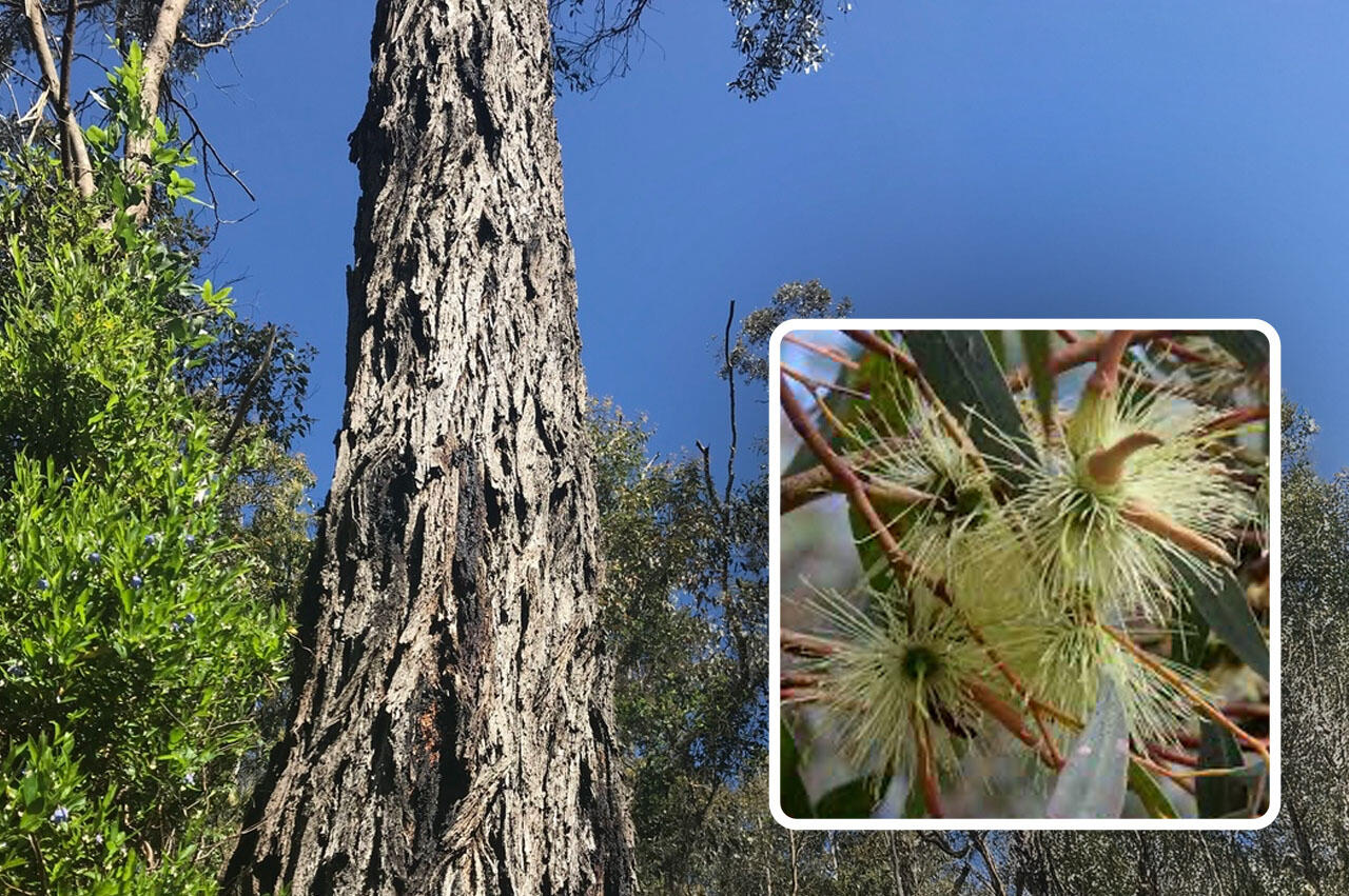
Marri (Corymbia calophylla) is a large, common tree to 60m height with characteristic large, urn-shaped fruits (known as 'honkey nuts'), and chunky, tessellated, resin-oozing bark (the tree belongs to the bloodwood group of eucalypts); Feb - Apr flowering (white) on outside of canopy.
Blackbutt / Yarri
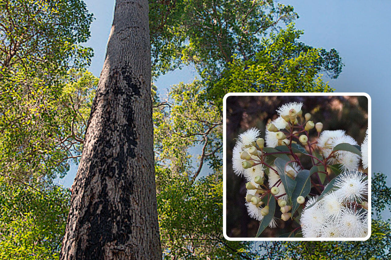
Blackbutt (Eucalyptus patens) is a large tree to 45m tall with rough, grey-brown furrowed bark which resembles the bark on jarrah and marri trees but is distinguished by having slightly smaller fruits than jarrah; Oct - Mar flowering (white).
Jarrah
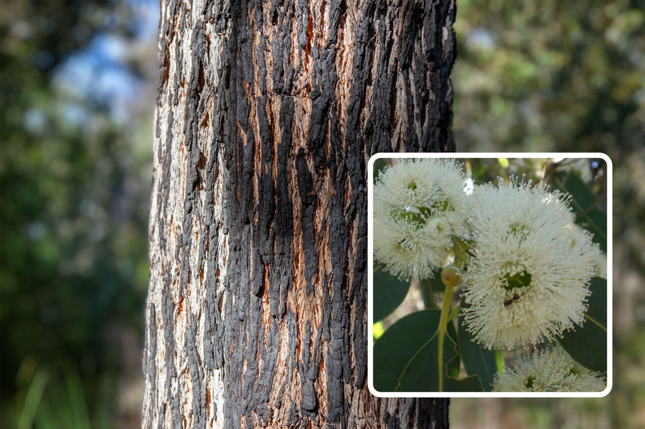
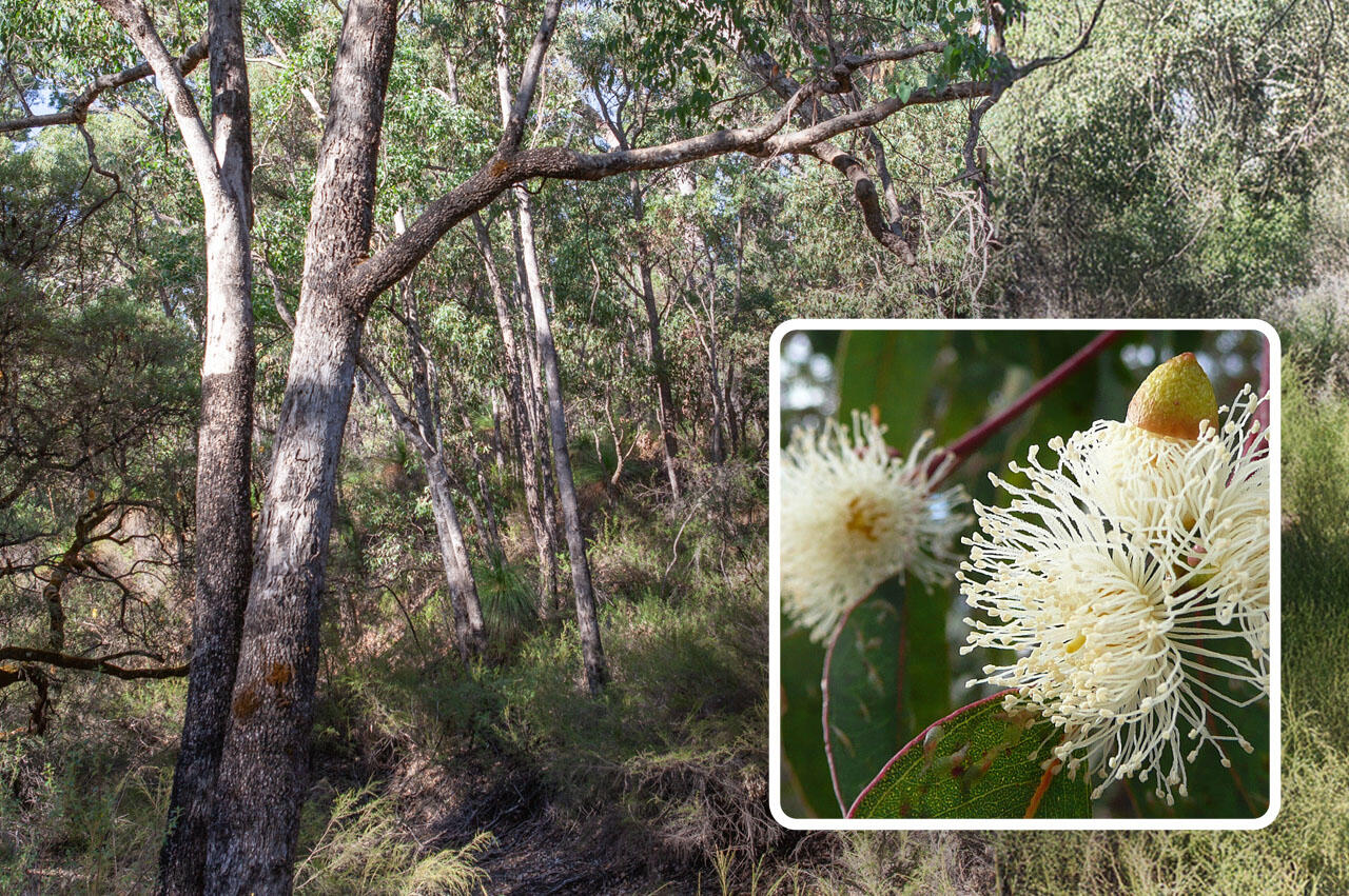
Jarrah (Eucalyptus marginata) is a common, large tree to 40m height with small fruits (gum nuts), stringy, fibrous bark with vertical fissures; Sep - Dec flowering (white).
Yate
Yate (Eucalyptus cornuta) is a small to medium size tree to 25m height with dark, shaggy bark on its lower trunk, and has distinctive long, horned flower buds. Also grows as a mallee (multiple stems); Jun - Sep flowering (large clusters of pale-yellow flowers).
Flooded Gum / River Gum
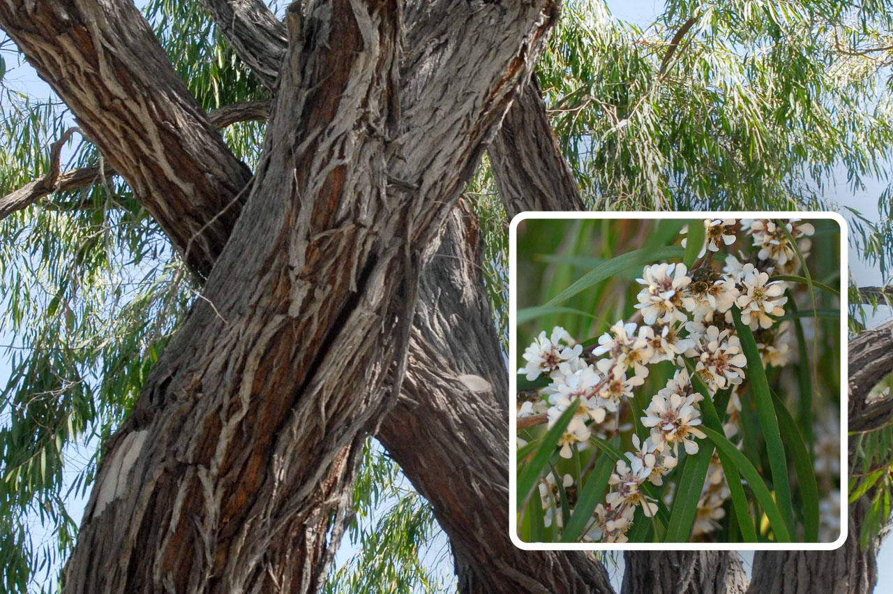
Flooded Gum or River Gum (Eucalyptus rudis) medium-size tree to 20m height with rough, grey bark on the trunk and smooth, grey bark on branches.; Jun - Sep flowering (white).
Sheoak
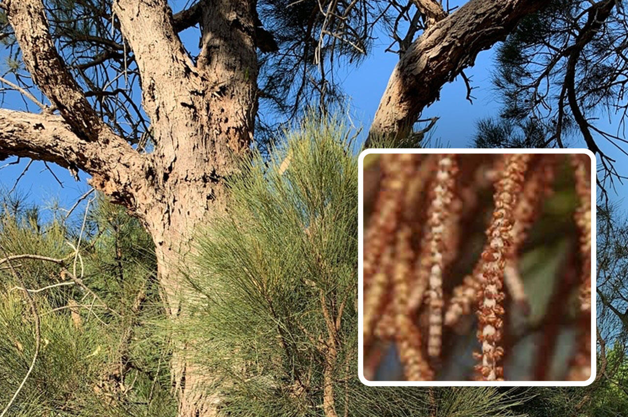
Sheoak (Allocasuarina fraseriana) is common in jarrah forest and eucalypt - banksia woodlands. It is a small to medium size tree to 15m height with rough, fibrous bark and green, needle-like, segmented leaves which are actually branchlets; the leaves being tiny triangular 'teeth' at one end of each segment. The female tree produces rough, woody bracts/cones, often seen on the ground below the tree; Apr - Sep flowering by the male tree (profusion of tiny rusty brown flowers).
Peppermint
Peppermint (Agonis flexuosa) is a small to medium-size tree to 10m height with weeping branches and narrow, pendulous leaves (strongly aromatic when crushed); Sep - Feb flowering (white).
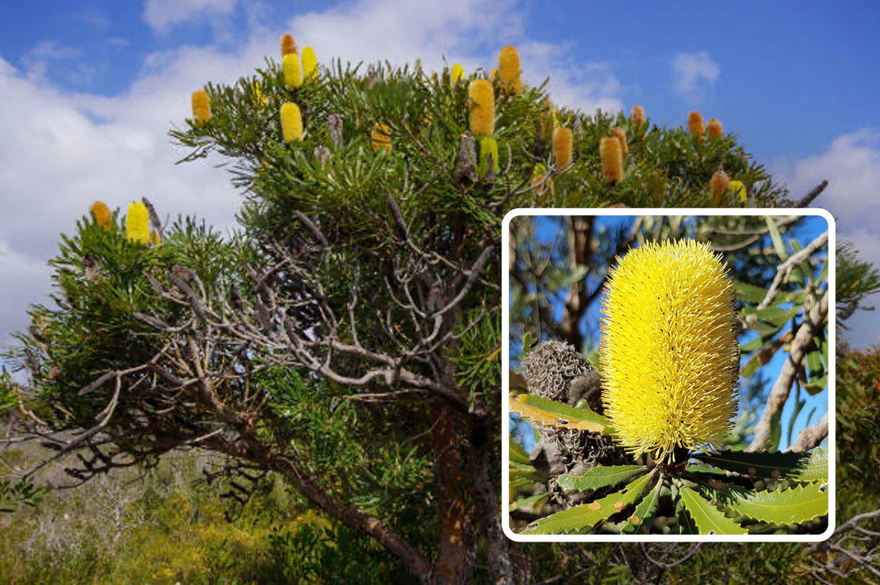
Candle Banksia
Candle banksia (Banksia attenuata) is a common small tree to 10m height, with leathery, finely serrated leaves and slender candle-like, sulphur-yellow flower spikes; Sep - Mar flowering.
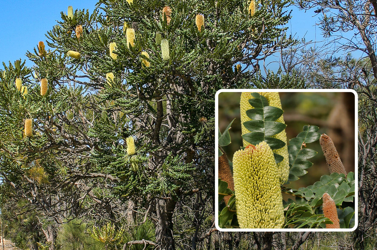
Bull Banksia
Bull banksia (Banksia grandis) is the most common banksia in the jarrah forests and mixed woodlands, and in karri forest, growing to 10m height. It has distinctive, deeply serrated, leathery leaves and large golden-yellow flower spikes; Sep - Mar flowering.
River Banksia
River banksia (Banksia seminuda) grows to 20m height, usually with a straight trunk and tough, fissured grey bark, and as the name suggests, along watercourses in jarrah, marri and karri forests. Its leaves are leathery and finely serrated; Mar - Aug flowering.
Specialised Education Tutorials
Dr Peter Russell, Geologist and Ecologist, is available for specialised education tutorials. To enquire, you can find his details in the Nannup WA Geopark app under the Tour Guide section.Without the generous knowledge sharing from Peter we would not have this world first citizen science carbon measuring program.
See the SCEA Results
Data recorded and submitted for SCEA will be shown below. Complete map coming soon.
Representation
The Australian Geoparks Network
The formation of Geoparks Australia and Geoparks WA
Overview
The Australian Geoparks Network (AGN) has been in existence in various forms since 2008. Almost a decade later some of the leaders of the AGN established Geoparks Western Australia (Geoparks WA), in our largest state. In so doing this their aim was to also formalise the AGN. This was the focus of Geoparks WA and over the period 2019-20 and which has now occurred when it was incorporated in Western Australia in 2021.


The organisation has an Australian wide Board made up of members with expertise in geoparks, geotourism and geotrails with others having expertise in geology, tourism and / or education. One is the former Director of Australia’s first global geopark, Kanawinka which operated from 2008-2012. Another helped establish the Oki Islands UNESCO Global Geopark in Japan.The Australian Board is supported by an International Advisory Board comprising geopark specialists from around the world. They include world leaders of the Geoparks Movement; three country geopark network chairs; and other major contributors to the development of global geoparks.
Collective Objectives
To mentor, support and promote the development of geoparks, geotourism, geoheritage, and geotrails in Australia.
To facilitate the marketing collectives for geoparks, geotourism, and geotrails in Australia.
To encourage stakeholder participation and collaboration in the establishment of geoparks in Australia.
To cooperate with like-minded entities and individuals in promoting all aspects of tourism visitation related to geological attributes of our Australian environment.
What's Next for Geoparks WA?
Since incorporation, several workshops have been held as both public and team events. Geoparks WA has showcased the business of geoparks, and cultural and environment aspects. Public workshops have included interstate and international geopark specialists and have been well received. Team events have focused on discussing development of geoparks locally with active teams and to share information between the teams.There is a growing level of interest in geoparks in Western Australia and membership, which remain free to date, continues to increase. The board of Geoparks WA maintains positive links with both government agencies and elected representatives, and private businesses across the State.Geoparks WA board members worked initially with the Murchison GeoRegion and Geopark along with the Forum Advocating Ecotourism and Culture and following that success, has since worked with Wanneroo / Joondalup, Binjareb / Peel and Nannup WA Geopark as they move forward with their geopark projects.
Geoparks WA is also active in attracting grants and other funding in its promotion of geoparks. This has included a Regional Arts Australia grant to establish a Genestream project at Kellerberrin linking Aboriginal Culture to Earth and Biota of the Wheatbelt Region, a Regional Development Commission grant to design and establish a geodrive in the Mandurah, Murray, and Waroona shires and to provide a consultancy to both Mid West and Peel Development Commissions.The board of Geoparks WA continues to lobby at State and National levels. Geoparks WA liaises with State members of Parliament and directors of government agencies and is represented on the Geological Survey Western Australia geotourism workshops.Geoparks WA also engages with federal politicians and agencies to promote geoparks. Representation is also made on the Working Groups for the Australian Geoscience Council National Geotourism Strategy. Several board members are members of the geological Society of Australia and work with the State branch, GSA WA.
The Future of Geoparks Australia
While the AGN is active in promoting geoparks in Australia, it remains aware that a future role will be to the Australian Board will be changed to model the UNESCO Global Geoparks National Committee framework. That is, it will comprise representatives of each of the following government departments or equivalent not-for-profit organisations:
UNESCO Global Geoparks
The Australian Geoparks Network (Geoparks Australia)
The Geological Society of Australia or Geoscience Australia
The Australian Conservation
The National Indigenous Australians Agency
Australian National Commission for UNESCO
National committee for the International Geoscience Program (IGCP)
Any additional members that may be relevant for the Committee
At the time of establishment of the UNESCO National Committee as the substantive AGN Board, the members of the existing Board will transition to being members of an Advisory Committee to the AGN. The International Advisory Board will remain in place throughoutThe Chair of the AGN has regularly met with senior Federal and State Parliamentarians, Departmental Heads of Agencies, and community organisations. A newsletter is regularly published outlining Global Geopark events and promoting conferences, the status of UNESCO Global Geoparks on a global basis and the progress of Australian geoparks.
Get involved
Nannup WA Geopark Membership
Become a part of Nannup WA Geopark history
Membership Benefits
In addition to being a proud volunteer of Nannup WA Geopark, you also receive these benefits as a Member...

Receive Member Newsletters

Access to Field Trips + Info Sessions

Conduct Citizen Science Programs

Record Results in Our Database

Fees Help Develop Education Material

Fees Help Develop Geopark Trails
PLEASE NOTE - Before you become a Member, you will need to acknowledge that you are aware of our Constitution and Membership requirements.
Interested? Join Today
For only $20 per year, you can become a Nannup WA Geopark right now - join below.
Already a Member?
Access the exclusive Members Only Area with your Membership details - log in below.
You are logged in
Members Only Area
Welcome to the Nannup WA Geopark Members Area
This exclusive area of our website serves as an information hub for Nannup WA Geopark Members. Here we will be introducing the ability to access Geopark Trail data as well being able to submit your own findings.Our Member newsletter as well as notifications of field trips and information sessions will also be published below. We will notify you via your supplied contact details (email or phone) when we publish information. Thanks for your patience.
Newsletter
Coming soon.
Field Trips
Coming soon.
Info Sessions
Coming soon.
Need to Update Details?
You can update your personal details and manage your membership below.
Member Log Out
To help protect your Membership access, be sure to log out with the button below.
Nannup WA Geopark
Disclaimer
Nannup WA Geopark App and Website Disclaimer
By using the Nannup WA Geopark app and website, you agree to abide by the terms and conditions in this disclaimer.
Use at Your Own Risk: The use of the Nannup WA Geopark app and website is at your own risk. Nannup WA Geopark holds no responsibility for any damages, whether intellectual or physical, incurred while operating the app and website.
Accuracy of Information: The information provided on the app and website is published in good faith at the time of publishing. However, Nannup WA Geopark does not guarantee the accuracy, completeness, or reliability of the information. Users are advised to verify any information before relying on it.
Non-Legally Binding: The information provided on the app and website is not intended to be used for legal purposes. Users should seek professional advice for legal matters.
Restrictions on Use: Information obtained from the app and website cannot be copied or used for financial gain without explicit permission from Nannup WA Geopark.
Copyright: The copyright of photos and other content belongs to the creators where copyright ownership is indicated. Any unauthorized use of copyrighted material is prohibited.
No Endorsement: The inclusion of any external links or references on the app and website does not imply endorsement by Nannup WA Geopark. We have no control over the nature, content, and availability of external sites.
Changes to Disclaimer: Nannup WA Geopark reserves the right to modify or update this disclaimer at any time without prior notice. Users are encouraged to review this disclaimer periodically for any changes.